Overview
Sunkoshi Rural Municipality, Sindhuli (सुनकोशी गाउँपालिका, सिन्धुली):
Sindhuli is a hilly district located in the central part of Janakpur Zone under the former Central Development Region on the map of Nepal. Naturally, this district is a hilly region from the plains of the inner Madhes. Spread from the Chure region of the Terai to the hilly Mahabharata, this district is spread east and west almost like a map of Nepal. The district headquarters is at Sindhulimadhi.
Sindhuligadhi is an important place in terms of natural beauty and history. This place is about 150 kilometers east of Kathmandu. Located at an altitude of 4,648 feet, this area is also naturally beautiful. Due to the hot, subtropical, and temperate climate of the district, flora and fauna are also diverse. The availability of both woody and woody vegetation is a feature of this district's forests. Forests cover about 64% of the total area of the district.
The current political and administrative divisions:
Provinces: - Bagmati Pradesh of the Federal Republic of Nepal,
Name: Sunkoshi Rural Municipality Executive Office, Sindhuli
Development Region: - Central Development Region
Zone: -Janakpur Zone
District: - Sindhuli
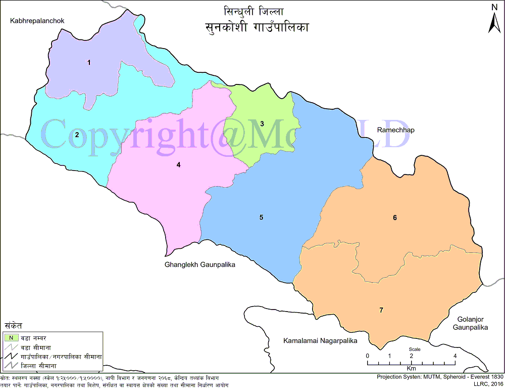
Number of Ward: -7
Center: - Office of Savik Purana Jhagajholi VDC,
Currently included VDCs: Kusheshwar Dumja, Jhagajholi Ratamata, Old Jhagajholi, Sitalpati, and Mazhuva
Population and households as per National Census 2068:
Total population: 21473
Male: - 9988 and female: - 11485
Total Households: - 4557
Border:
In the east: Golanjar village municipality and Ramechhap district
In the west: Kavrepalanchok district
In the north: - Ramechhap district
In the south: Ghyanglekh rural municipality and Kamalamai municipality
Geographical location: Total area: 154.68 sq. Km.
Geographical Map of Sunkoshi Rural Municipality:
Contact Address:
Location: Sunkoshi Gaupalika, Ramtar, Sindhuli, Bagmati Pradesh, Nepal
Telephone: +977-1-6924118
Email: info@sunkoshimunsindhuli.gov.np
Website: www.sunkoshimunsindhuli.gov.np


