Overview
The Ramechhap district has been divided into 8 local levels and 2 constituencies with effect from the date of 2073 Falgun 27 the Government of Nepal. The center of the Doramba Sailung Rural Municipality (Gaupalika) (दोरम्बा शैलुङ गाउँपालिका, रामेछाप) is Doramba-3, Thamchaur. Doramba Gaupalika is bounded on the north by Dolakha district, on the south by Sindhuli, on the west by Kavrepalanchok, on the east by Okhaldhunga and Solukhumbhu.
Doramba Rural Municipality is located in the northwestern part of the Ramechhap district. It is made up of six VDCs including Savik Daduwa, Doramba, Tokarpur, Goshwara, Lakhanpur, and Gunsi. The geographical location, historical identity, and nomenclature, political location, natural and cultural excellence, development prospects of this rural municipality with hilly features under Bagmati Pradesh are explained in the following headings.
Ramechhap is a Himalayan district located in the Janakpur Zone of Bagmati Pradesh, Nepal. Although close to the capital, it is a remote area in terms of service facilities. Kavrepalanchok district, which is touched by the capital, lies between Dolakha and Okhaldhunga districts bordering China and Sindhuli district, which is touched by the Terai. This district of 1546 sq. Km is neglected despite having sufficient resources. Ramechhap is also known as the district of Tintal. Subba Krishnalal Adhikari, Martyr Ganga Lal Shrestha, and Founder General of the Communist Party of Nepal Pushpalal Shrestha were born in Ramechhap.
Ramechhap has produced all the talents of Nepali political art, literature, industrialists, businessmen, scholars, cultural workers, and media workers. Geographically, Ramechhap is one of the six districts of Janakpur Zone. According to the decentralization regulations of 2056, this district now falls in the category of inaccessible. The geographical extent of the district extends from 27 degrees 28 north latitude to 27 degrees 50 north and from 85 degrees 50 east longitude to 86 degrees 35 east. The topography of Ramechhap district extends from the central Mahabharata mountain range to the high mountain range, from 426 meters above sea level to 6958 meters to Numbur Himal Chuli.
Geographical location:
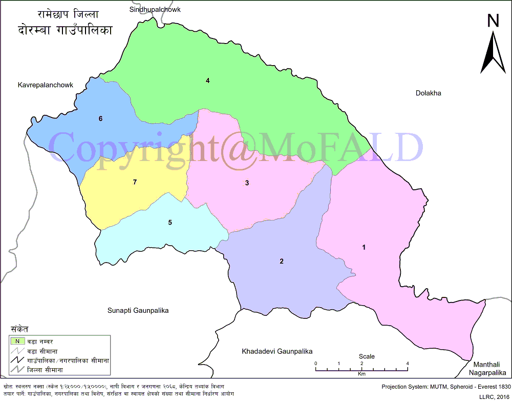
Doramba village, situated at an altitude of 715 m to 3138 m above sea level, is geographically situated at 27 degrees 28 minutes 41 seconds to 27 degrees 36 minutes 52 seconds north latitude and 85 degrees 49 minutes 27 seconds to 86 degrees 1 minutes 30 seconds east longitude. Doramba village municipality is located in the northwestern part of Ramechhap district. It is bounded on the east by Manthali Municipality and Dolakha District, on the west by Kavrepalanchok District, Sunapati Rural Municipality, and Khandadevi Rural Municipality and on the north by Dolakha District. Occupying 8.99 percent of the total area of the district.
Historical Identification and Naming:
Doramba Sailung Rural Municipality is a region with historical, religious, cultural, and natural features. Daduwa, Doramba, Tokarpur, Goshwara, Lakhanpur, and Gunsi VDCs under the former Doramba area. Doramba rural municipality was formed in 2073 BS. This rural municipality is one of the major areas of historical and tourist importance. Agleshwar, Shillong, Sano Shillong, Kantheshwar Temple, and Brahma Vishnu, which are of special religious and historical importance, still exist. Indigenous tribes live in large numbers here. The word Doramba is also associated with the Tamang language and culture of the indigenous tribes. In the Tamang language, do means 'two' and ramba means 'means'. Mane Tamang is a sacred place of worship according to culture. It is believed that Doramba came into being in the sense of two meanings of the Tamangs and later the name of this place became Doramba. This rural municipality seems to have been named after the two sacred places of worship, namely Doramba.
Ground conditions:
Doramba Rural Municipality of Ramechhap district under Bagmati Pradesh is hilly and high hilly terrain. In terms of topography, the area is covered by large snowfall in Shillong, Rajmantar, Lakhanpur, natural resources for paddy production, green land full of food grains, general slopes, and rocky areas. This rural municipality is made up of simple high and steep hill ranges and has a diverse topography including the surrounding settlements. Most of the slopes are covered by forests while some areas are deserted hills.
Natural Resources:
Chauri Khola, Ghatte Khola, and Dhobi Khola are the main natural resources of the village. Irrigation services are available from these rivers which are the main source of irrigation in the lands of the lower Vesi region. Pakhanveda, Katuki, Satuva, Vishjada, Chauri, Sheep, Cattle, Buffalo, Goat, Raga, Danphe, Kalij, Deer, Bear, Leopard, Rabbit, Sparrow, Tiger, Crow, Peacock Are in the form. Apart from this, there are forests and meadows in most parts of the upper part of the hill, and minerals including limestone and copper mines are found in this area.
Cultural Excellence:
Magar, Tamang, Sherpa and other indigenous tribes live in this rural municipality is a unique confluence of Hindu culture. Nepali is the main working and spoken language in this rural municipality which has a mixture of indigenous tribes, Chhetri, Brahmin, and Dalit castes. Religiously, Hindus and Buddhists predominate in this region. Among the festivals celebrated are Dashain, Tihar, Lhochhar, Bhadra Purnima Mela, Kukhure Ahal Purnima Mela, Sano Shailung, Poush Purnima Mela, Pudighyang Shravan Purnima Mela, Thulo Shilung Ekadashi Mela, etc.
Religiously and linguistically similar in this region, the various activities carried out during the festivals reflect the social and cultural excellence of the place. Indigenous people have their own style of dress while in other cases, men mainly wear Daura, Surwal, Topi, and Kot, and women wear guys choli, Patuki, and Bulaki. Religious places like Agleshwar, Shailung, Sano Shailung, Kantheshwar Temple, Brahma Vishnu are important cultural heritages in this village.
Geographical Map of Doramba Rural Municipality:
Contact Address:
Location: Doramba Sailung Gaupalika-3, Tokarpur, Ramechhap, Bagmati Pradesh, Nepal
Telephone: +977-9854043969
Email: ict.dorambamun@gmail.com
Website: www.dorambamun.gov.np


